COUNTY PARCEL MAP - BUFFER CONTROLS
Buffer Controls are used to locate other parcels
within a user-specified distance of an initially-selected parcel group. The Select
Parcel Tool as found on the
Tools menu is the best
means to designate an initial parcel group. The Buffer Control is activated by the
Buffer button also found on the Tools menu.
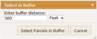
To use the Buffer Control follow these steps:
- Enter Buffer Distance: enter the numeric distance from the seed parcel
group.
Note that distances which yield a parcel count greater than one hundred
are not supported and may cause a processing error.
- Units: select the desired buffer distance units (feet or miles).
- Select Parcels in Buffer: pressing this button begins the buffer process.
The result of this action will be a set of parcels within the specified
buffer distance.
- Cancel: pressing the Cancel button will close the Buffer Control without
further action.