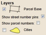
COUNTY PARCEL MAP - SEARCH TAB - LAYERS
The Layers control as found on the
Search Tab is used to manipulate the view of
County parcels in terms of labels and city boundaries. For example, use this
control for zooming the
map to specified locations, or selecting one or many parcels based up
common location parameters. Key parameters include:
- Parcel Base: to view parcels, ensure this box is checked.
- Show Street Pin Numbers: check this on to tag each parcel
with a
Push Pin.
- Show Parcel Number: check this box on to view parcel number
as a label on the parcel. The parcel number may also be found on
the Push Pin. Use of the parcel
number label and Push Pin will allow the simultaneous viewing of
address and parcel number.
- Cities: check this on to place a yellow background to
highlight incorporated areas within the County.