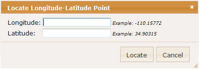
To use the Latitude and Longitude Control follow these steps:
- Longitude: enter the desired longitude value. County values will require
a minus (-) sign. At least five decimal palaces will be required to locate
a sign, and four decimals to find a parcel.
- Latitude: enter the desired latitude value. At least five decimal palaces
will be required to locate a sign, and four decimals to find a parcel.
- Locate: pressing this button will locate the specified point and
zoom the map to the coordinate location.
- Cancel: pressing the Cancel button will close the Control without further
action.